


DIGITAL TERRAIN MODELS
Riskscape’s Digital Terrain Models (DTMs) and Digital Surface Models (DSMs) deliver ultra-high-resolution elevation data that reveal exactly how the land rises and falls beneath your feet. Whether you need the bare-earth topography for flood modelling or the full surface detail that includes buildings and vegetation, our models give you property-level accuracy to make confident decisions about risk, planning, and resilience across South Africa.


A NATIONAL STRATEGIC PARTNERSHIP
GeoSpace International, Hexagon, and Riskscape have joined forces to deliver the first homogeneous, high-resolution elevation dataset for all of South Africa. By combining world-class aerial data acquisition, massive cloud-based processing power, and advanced machine learning, this partnership has transformed 1.2 million km^2$ of imagery into a vital national asset.
GeoSpaceInternational
Leveraged the Leica DMC III airborne sensor to capture high-quality, 25 cm resolution imagery across the entire country.
HexagonUtilized the HxMap workflow and global Content Program infrastructure to process massive volumes of data, generating precise 1-meter Digital Surface Models (DSMs)..
Riskscape
Applied machine-learning algorithms and automated classification to extract vegetation layers, building footprints, and water bodies to derive accurate 2-meter and 5-meter DTMs.
INDUSTRIES WE EMPOWER
Insurance & Banking Precision flood hazard modelling.
Telecomm 5G network planning & signal propagation.
Environment Hydrological analysis & climate resilience.


WHAT IS A DSM VS A DTM?
DSM
Digital Surface Model (DSM) The same high-resolution grid, but this time it captures everything on the surface — buildings, trees, vegetation, and structures. Perfect for urban planning, visibility analysis, and understanding the full 3D environment above ground.
DTM
Digital Terrain Model (DTM) A grid where each pixel holds a single elevation value, representing the height of the Earth’s bare surface. Trees, buildings, and all other features are removed, giving you a clean map of true topography — essential for accurate flood and landslide modelling.
How We Collect the Data?
We create both our DTMs and DSMs using photogrammetry. A smarter, more cost-effective method than traditional LiDAR.

Photogrammetry vs LiDAR
Photogrammetry
Photogrammetry captures hundreds of overlapping drone or aerial photographs and processes them into a dense 3D point cloud. Ground points are then intelligently filtered to produce a pure DTM of the Earth’s bare surface, while the full point cloud can be used directly to generate a DSM that includes every tree, building, and structure. The result is a 2 m resolution grid that is fast to produce, affordable at scale, and perfectly suited for large-area applications such as flood and landslide modelling.
LiDAR
LiDAR fires laser pulses from an aircraft or drone to measure distances to the surface. While it can sometimes penetrate vegetation more deeply, it is significantly more expensive, requires specialised equipment and flight permissions, and is often overkill for the kind of property-level risk analysis we deliver. Our photogrammetry workflow therefore gives you the same high-quality elevation intelligence — only faster and at a fraction of the cost.
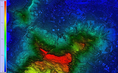
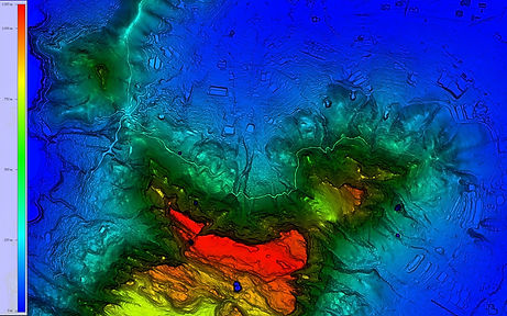
See the Difference in Cape Town
Real-World Comparison of Table Mountain in Cape Town

Photogrammetry DSM (1 m)
Full surface (buildings + vegetation)
LiDAR DSM (1 m)
Full surface captured by laser

Photogrammetry DTM (2 m)
Bare earth only

LiDAR DTM (1 m)
Bare earth extracted from LiDAR
Why Resolution & Method Matter?
-
Our 2 m DTM is ideal for flood modelling, water flows naturally from pixel to pixel.
-
1 m DSM gives planners and insurers the full picture of built-up areas.
-
Photogrammetry delivers the same detail as LiDAR, but faster and more affordably across entire provinces.