Property Identifier API

Point a phone at a building.
Find its point. Get its property key.

A photograph records where you stood and which way you looked. Riskscape uses that position and heading to locate the building point, return its address context and identify the stand, farm portion or scheme it belongs to, where available. Explore real captures from Pretoria, with building points and stands shown on our map.

No need to enter the propertyWorks where there is no street addressAn API your product calls
9:41GPS
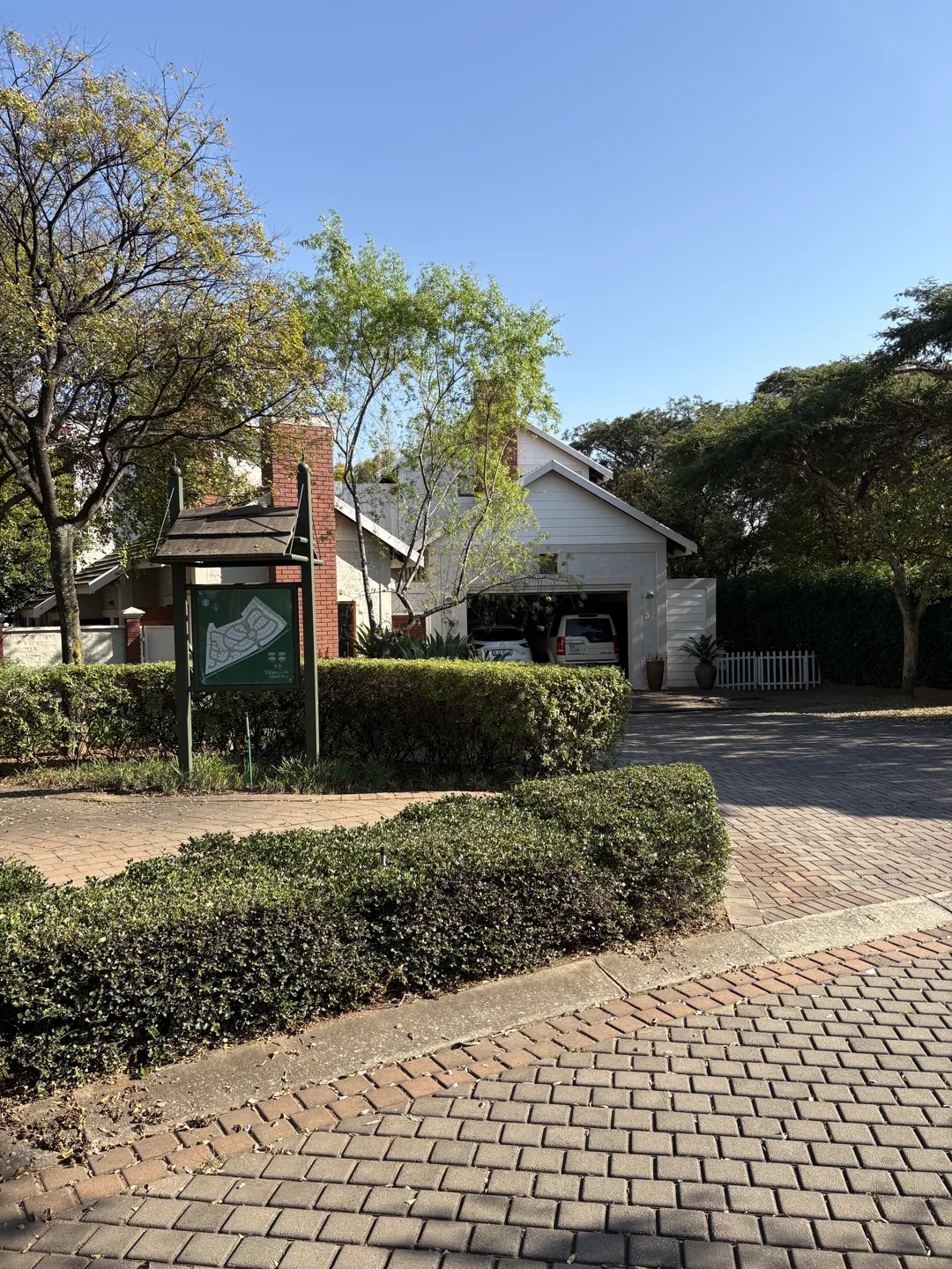
A home behind trees, photographed from the street in Woodlands Lifestyle Estate.
323° TRUE
Building point found

38 Feverwood Place

-25.823897, 28.305582
SG21 PROPERTY KEYT0JR01760000674800000

Capture walkthrough · recorded result
Tap the shutter to replay

Same position.
A different direction.

Explore the photos, map & response
The gap

The structure is right there. The record is not.

Every credit, insurance, delivery and account-opening decision assumes a verifiable address. For a large share of South African properties the address exists on the ground and nowhere in a database - so the fallback is a person at the gate, a form, and a delay.

Structures without street addresses

Settlements, farm dwellings, backyard units, new extensions and unnumbered business premises are all real and occupied - and unmatched by any lookup built on street data alone.

The same home, three ways

Spelling variants, missing extension numbers and unit numbers buried in a street field mean one property appears as several customers, and several customers appear as one.

Verification done on foot

A branch visit, a utility bill, an affidavit, a knock at the door. Manual proof of address is where time, cost, risk to the agent and abandonment all concentrate.
Real field examples

From the photograph to the property.

Choose a capture to see its original GPS and heading, the returned building point, and the stand it belongs to on the Riskscape map, where shown. Start with two neighbours photographed from exactly the same spot.

The field collection

Real photos. Real property records.

01 / The original captureIMG_0086.jpg
A home behind trees, photographed from the street in Woodlands Lifestyle Estate.
2025-05-19 · 09:27:44322.7° true north
02 / Locate the buildingRiskscape map
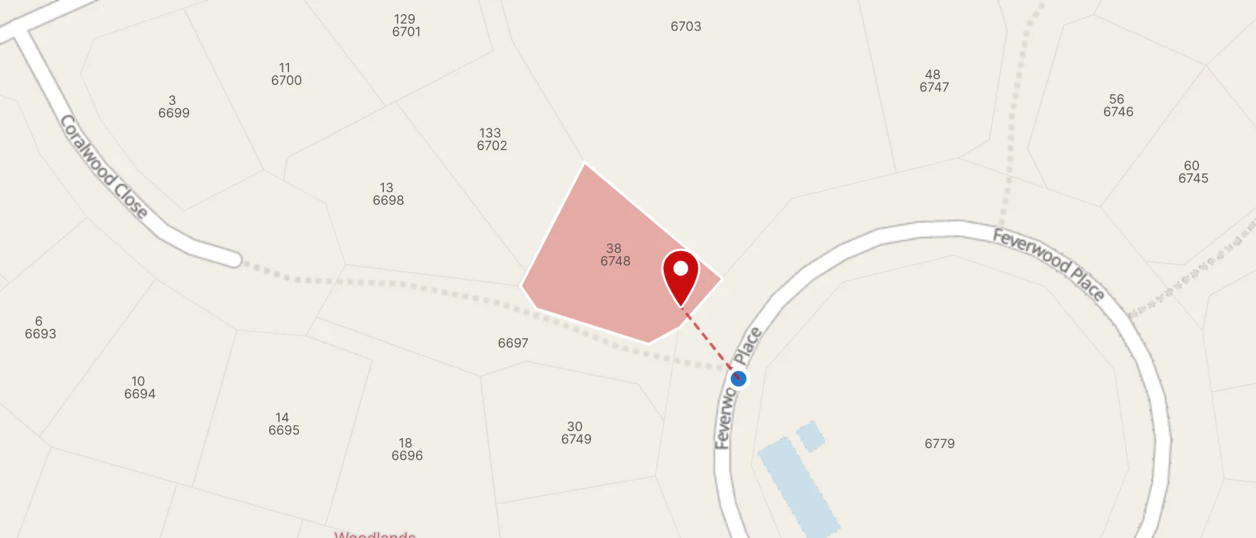
Riskscape map showing the capture position, building point and stand for 38 Feverwood Place
Powered by Riskscape © MapTiler © OpenStreetMap contributors
Photo GPSBuilding pointStand
03 / Returned building pointBuilding point found

38 Feverwood Place

38 Feverwood Place, Woodlands Lifestyle Estate, Moreletapark Ext 63, Pretoria, City of Tshwane, Gauteng

Turn the camera towards the neighbouring home. The capture position stays the same; the returned property changes.

SG21 property key
T0JR01760000674800000
Building point position
-25.823897, 28.305582
Building point type
stand_address
Scheme ID
RES-GP-003511
Inspect the request & response GET · JSON

Request from photo metadata

GET /api/addressing/v2/building-point
?lat=-25.824016666666665
&lon=28.305688888888888
&heading=322.74914559125085
&heading_ref=T

The original EXIF coordinates and decimal heading are sent to the building-point endpoint, preserving the magnetic or true-north reference.

Recorded lookup response

{
  "data": {
    "building_point_found": true,
    "building_point_type": "stand_address",
    "building_point_position": {
      "lat": -25.823897,
      "lon": 28.305582
    },
    "scheme_id": "RES-GP-003511",
    "property_key": "T0JR01760000674800000",
    "address": {
      "category": "StreetAddress",
      "subcategory": "StreetNumberMain",
      "street": "Feverwood Place",
      "street_number": "38",
      "street_number_type": "street_number",
      "cross_street": null,
      "complex": "Woodlands Lifestyle Estate",
      "major_complex": null,
      "suburb": "Woodlands Lifestyle Estate",
      "suburb_part": null,
      "suburb_extension": null,
      "subplace": "Woodlands Lifestyle Estate",
      "town": "Pretoria",
      "city_town": "Pretoria",
      "municipality": "City of Tshwane",
      "district": null,
      "province": "Gauteng",
      "province_code": "GP",
      "farm_name": "GARSTFONTEIN 374 JR",
      "farm_number": "374",
      "postal_code": "0181",
      "position": {
        "lat": -25.823897,
        "lon": 28.305582
      },
      "mapcode": "L6W.YFW",
      "plus_code": "5G6C58G4+C6",
      "full_address": "38 Feverwood Place, Woodlands Lifestyle Estate, Moreletapark Ext 63, Pretoria, City of Tshwane, Gauteng",
      "scheme_id": "RES-GP-003511",
      "suburb_id": "5747e1a6-5024-11ef-a9be-4173e64b4b7a",
      "subplace_id": "799035163-L6W.Y7L",
      "property_key": "T0JR01760000674800000",
      "erf_number": "6748",
      "portion_number": "0"
    }
  }
}
Photographs supplied from the field. Building-point and stand-boundary responses recorded on . The pin uses the returned building-point coordinates. Street-addressed examples also show the stand; the dwelling example focuses on its individual point. Map views are static captures of the Riskscape map, taken on .

building_point_found
Whether an existing building point was found. A false result must be handled as a projected position, rather than a confirmed building-point match.
Match
building_point_type
The kind of point returned. These captures include stand_address for street-addressed homes and building_point_on_stand for the informal dwelling.
Building
building_point_position
Latitude and longitude of the returned building point. This is where the red pin is placed, distinct from the photo’s GPS position.
Building
property_key
The SG21 identifier for the registered stand or farm portion, when available. Several buildings can share this property key while having different building points. A linked scheme is identified separately by scheme_id.
Property
scheme_id
The linked scheme or estate identifier, where available; otherwise null.
Scheme
address
Address and area context returned with the building point. This can be a street address or a relative location description where street addressing is unavailable.
Address
property_key
Deeds and ownership, legal description, municipal valuation, comparable sales, flood, wildfire and seismic exposure at the property.
Property
address
The returned address components and geographic context, including a subplace ID where available.
Address
scheme_id
The scheme and the units inside it, for sectional title exposure and unit-level records.
Scheme
address.subplace_id
Market Discovery - subplace demographics, income bands and consumer credit profile.
Area
Response excerpt · 38 Feverwood Place
{
  "data": {
    "building_point_found": true,
    "building_point_type": "stand_address",
    "building_point_position": {
      "lat": -25.823897,
      "lon": 28.305582
    },
    "scheme_id": "RES-GP-003511",
    "property_key": "T0JR01760000674800000"
  }
}

The building point locates the structure; property_key links it to the registered stand or farm portion. The full response, including address, is available in the field examples above.

The SG21 property key

Once you hold the key, you can pull anything you have rights to.

A property match gives you an SG21 code for the registered stand or farm portion. Store it with the capture, then use it to request the property information your application needs, under your organisation’s data entitlements.

SG21 property key

T0JR01760000674800000

One property. One key. Stable across systems and over time - and the same key whether the photo came from your app or ours.

Deeds & ownershipRegistered owner, legal description, transfer history
ValuationMunicipal value and comparable sales on the erf
Flood & wildfirePeril exposure scored at the structure, not the suburb
Seismic hazardProbabilistic ground motion for the site
Market & demographicsSubplace income, credit and household profile
What a photograph unlocks

Real captures. Practical next steps.

These photographs show how a returned property reference can fit into finance, assessment and fieldwork. Downstream decisions remain part of your own application.

Property finance · customer capture

“Which of these two houses do you mean?”

The two Feverwood photographs share a GPS position. Their headings resolve to different neighbouring properties, giving your application the right key to request property information.

9:41GPS
A home behind trees, photographed from the street in Woodlands Lifestyle Estate.
323° TRUE
Building point found

38 Feverwood Place

-25.823897, 28.305582
SG21 PROPERTY KEYT0JR01760000674800000

Capture walkthrough · recorded result
Tap the shutter to replay

38 Feverwood Place

One position. Two different erfs.

38 Feverwood Place returns erf 6748. Turn the camera and 30 Feverwood Place returns erf 6749. Valuation and credit decisions are separate steps.

RETURNED SG21T0JR01760000674800000
Inspect the field examples

Insurance · roadside assessment

“That is the property I came to inspect.”

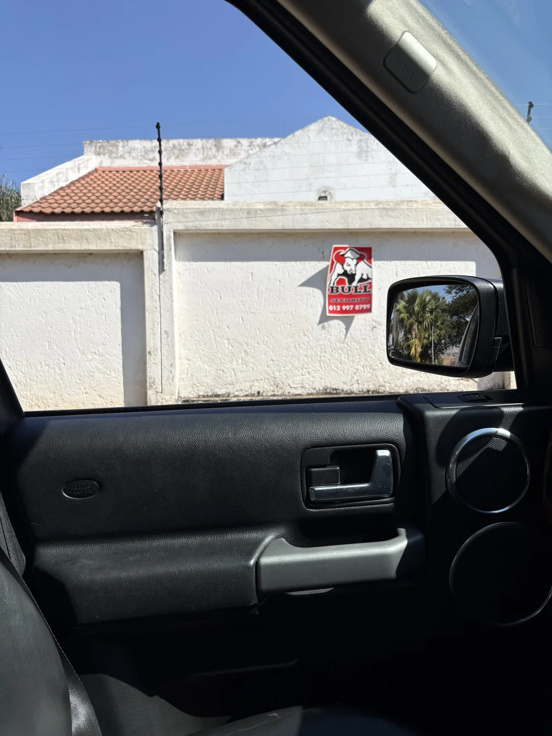
A photo through the passenger window carries the location and magnetic heading. The returned key gives an assessor a property reference to attach to the inspection.

9:41GPS
A house and boundary wall photographed through the passenger window of a vehicle.
279° MAGNETIC
Building point found

861 Frhensch Street

-25.833089, 28.285935
SG21 PROPERTY KEYT0JR01760000446000000

Capture walkthrough · recorded result
Tap the shutter to replay

861 Frhensch Street

A roadside photo, tied to an erf.

This capture resolves to 861 Frhensch Street. Store the returned key with the photograph, then request the risk layers your organisation uses.

RETURNED SG21T0JR01760000446000000
Inspect the field examples

Fieldwork · informal dwellings

“There is no house number to capture.”

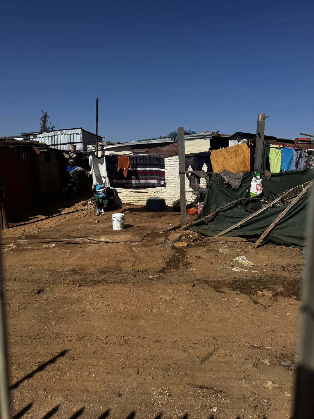
The photo shows dwellings beside a dirt path. The lookup finds a building point for the dwelling and returns its coordinates, relative address and the SG21 key for the farm portion it stands on.

9:41GPS
Informal dwellings with corrugated roofs beside a dirt path in Moreleta Park.
130° TRUE
Building point found

A dwelling in Moreleta Park

-25.830448, 28.307178
SG21 PROPERTY KEYT0JR00000000037400645

Capture walkthrough · recorded result
Tap the shutter to replay

A dwelling in Moreleta Park

A dwelling point within the larger stand.

The building_point_on_stand result places this dwelling at −25.830448, 28.307178. Its SG21 links to portion 645 of farm 374; the point locates the dwelling within that farm portion.

RETURNED SG21T0JR00000000037400645
Inspect the field examples
Where else it fits

Anywhere someone has to prove which building they mean.

The capture is identical every time. What changes is the system on the other side of the API.

Onboarding

KYC and FICA evidence

Attach a property reference to an onboarding record, alongside the evidence and checks your verification process requires.
Logistics

Proof of delivery

Bind the drop to a property rather than a pin in the street, so a disputed delivery has an erf attached to it.
Fieldwork

Inspection and assessment

Valuers, assessors and meter readers capture from the vehicle where stopping and walking in is slow or unsafe.
Municipal

Faults, assets and billing

A reported fault, a municipal building, a meter or a rates query lands against the erf it belongs to.
Commercial

Merchant and SME onboarding

Associate a field capture with a property reference as one input to merchant onboarding and premises verification.
Existing data

Verify what you already hold

Standardize a book and collapse duplicates onto one property key, so the same property stops appearing as three customers.
Build with it

One API. Your product around it.

Riskscape does not sit between you and your customer. The identifier is a service your own application calls, inside your own flow, under your own brand.

One endpoint

Send latitude, longitude, heading and the heading reference to GET /api/addressing/v2/building-point. The result includes the building-point coordinates, match status, address context, SG21 property key and scheme ID where available.

Capture inside your own app

The camera step belongs to your product - a banking app, a field app, a registration tool. We supply the resolution behind it and a reference implementation showing the capture flow that works.

Scoped to your entitlements

Lookup access and downstream data are scoped to your organisation. A building-point result can carry the SG21 property key and a separate scheme ID; deeds, valuation, peril and demographics are separate requests under the relevant entitlements.

What we will need from you

A short technical call is usually enough to scope it. It helps to know:

  • What your application does, and where the capture step would sit in it
  • Whether captures come from staff in the field, from your customers, or both
  • Expected call volume, and whether it is steady or campaign-driven
  • Which downstream layers you need attached, and what rights you already hold to them
  • Whether the result feeds a compliance file, a credit decision, a risk model or an operational system

We will run captures from an area you choose so you can see the match rate before anything is signed.

Send us photographs from your hardest area.

Wherever your current process gives up - no street names, new extensions, backyard units, unnumbered business premises. We will resolve them and show you what came back.